
Why Boundaries Matter
Boundaries are important — especially when it comes to New Mexico’s water.
Mar / 2024

Water is the lifeblood of New Mexico’s communities — but we face a future with less water. This means that the vitality of our cities, towns, agriculture, and ecosystems depend on us planning and taking action today. But what does this look like in practice? How are water plans created? Who decides what infrastructure is built or repaired? And how are those projects funded?
These are really important questions (vital even), and with the help of Angela Bordegaray, a seasoned water planner and native New Mexican with over 20 years of experience in desert water systems, we’re here to put some of the pieces of this puzzle together.
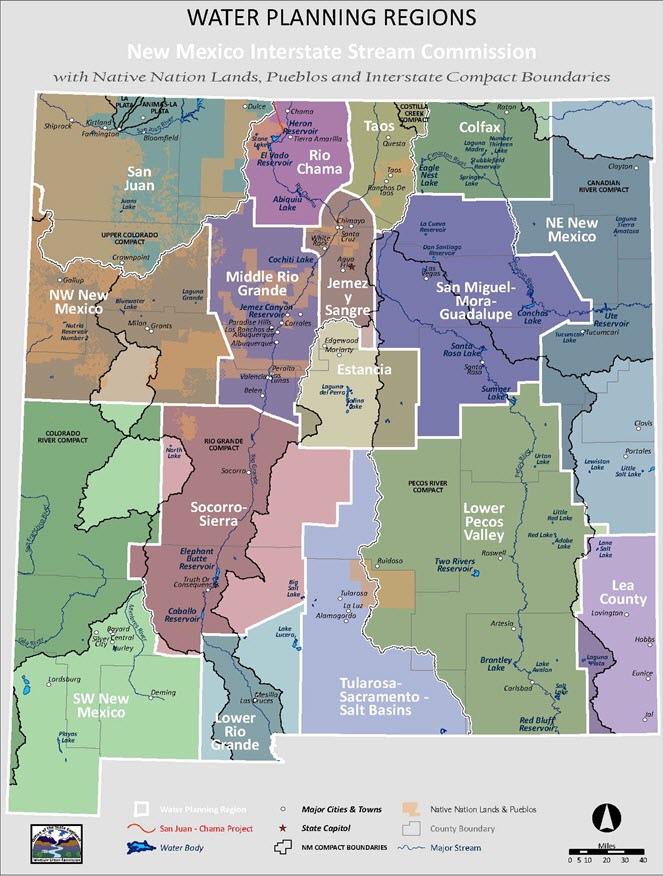
Where water planning and infrastructure projects begin: water regions
Water resources vary a lot across a state as large and diverse as New Mexico. What works in the arid southwest looks different than what works in the mountainous northeast or on sovereign tribal land. That’s why water plans and infrastructure projects in New Mexico need to start from the ground up. They come from within each community, and this is done through New Mexico’s 16 water regions (which will be changing soon — but more on that later).
Angela suggested imagining water regions like mini-governments; they are often composed of a mix of elected officials and water or community leaders who work together to make decisions that directly impact people and communities on the ground. Angela explains, "Regions guide... They create the plan, make decisions about what is needed, and pursue and receive funding for projects that help meet those needs."
New Mexico’s 16 regions were drawn up decades ago. In most cases, they follow political boundaries (counties, cities, etc) or watersheds and rivers. Political boundaries are useful when it comes to project funding, facilitating federal and state funds for localized water projects. Watersheds and rivers, on the other hand, create intuitive borders based on natural resources.
When describing today’s water regions, Angela was sure to note: "There’s no right answer about how water regions and boundaries should be drawn." Like any map, it will never match the territory, and when it comes to water, there are not only political and natural resource considerations, there are cultural dimensions. Angela emphasized, "Culture plays a significant role in water management, particularly in New Mexico, where various stakeholders have significant influence.” Effective water regions need to consider the values, norms, and traditions of the communities they represent alongside political and hydrological factors.
So, what is next for New Mexico’s regions?
While a water region can never be perfectly drawn, this year there is an opportunity to revisit regional boundaries, and define the rules and guidelines that will govern New Mexico’s regional water planning efforts into the future. This important process is happening through the Interstate Stream Commission’s implementation of the Water Security Planning Act. Public engagement is at the center.
So, when it comes to the question of who decides the future of New Mexico’s water infrastructure, the answer starts with you. Your input in open houses this spring and summer will help create updated regional boundaries, rules and guidelines, which will have implications for the future of New Mexico’s regional water planning for years to come.
Now is the time to get involved and voice what matters to you.